
 English
 العربية
Marine Surveys and Modelling Studies
Understand marine conditions. Anticipate project impacts. Plan coastal development with confidence.
ETLCO provides marine surveys and modelling studies to help developers, industrial operators and consultants understand the environments in which their projects operate.
Our services combine field measurements, ecological surveys, laboratory analysis and numerical modelling to assess existing conditions and predict potential changes associated with coastal and offshore activities.
We support projects involving ports, marine terminals, desalination facilities, industrial outfalls, dredging, coastal infrastructure and offshore developments. Each study is tailored to the project’s location, environmental sensitivities and applicable requirements, including those of the National Center for Environmental Compliance (NCEC) and Royal Commission Environmental Regulations (RCER), where relevant.
Connect Field Evidence with Better Project Decisions
A well-designed marine study helps your team understand site constraints before they become operational or environmental challenges.
ETLCO’s integrated approach helps clients:
Establish baseline marine environmental conditions.
Identify sensitive habitats and ecological receptors.
Understand currents, water circulation and discharge dispersion.
Evaluate potential effects of dredging and coastal construction.
Compare project layouts and mitigation options.
Develop appropriate monitoring programs.
Prepare technical evidence for environmental assessments and regulatory review.
Marine Survey Services
1. Marine Habitat Mapping
We identify and map marine habitats to support project planning, biodiversity assessment and environmental protection.
Depending on the location and agreed scope, surveys may cover:
Coral reefs and associated communities.
Seagrass beds.
Intertidal and shallow-water habitats.
Sandy, muddy and rocky seabed areas.
Ecologically sensitive areas within the project’s potential influence.
Habitat maps help teams identify areas requiring avoidance, additional investigation or specific mitigation measures. Survey methods and classification detail are selected according to water depth, visibility, site access and study objectives.
2. Marine Water Quality Monitoring
ETLCO develops marine water quality monitoring programs to characterize baseline conditions and assess changes during construction or operation.
Programs may combine scheduled sampling, field profiling and continuous measurements where appropriate.
Parameters may include:
Temperature and salinity.
pH and dissolved oxygen.
Turbidity and total suspended solids.
Nutrients.
Metals and petroleum hydrocarbons.
Other chemical or microbiological indicators relevant to the project.
Monitoring locations, depths and frequency are selected to reflect discharge sources, currents, sensitive receptors and applicable assessment criteria.
Results help clients investigate changes, assess treatment or discharge performance and evaluate the effectiveness of environmental controls.
3. Benthic and Sediment Surveys
We assess seabed conditions, sediment characteristics and benthic communities to understand the marine environment and potential effects of project activities.
The scope may include:
Sediment sampling and physical characterization.
Particle size distribution and organic content.
Analysis of contaminants relevant to site history and proposed activities.
Assessment of seabed-dwelling organisms.
Comparison between potentially affected and reference locations.
Evaluation of changes associated with dredging, construction or operational discharges.
These findings support environmental impact assessments, dredging studies and the design of monitoring programs.
4. Marine Species and Biodiversity Studies
ETLCO develops project-specific surveys to assess selected marine species and ecological communities.
Depending on the study objectives and specialist requirements, the scope may address fish, invertebrates, marine mammals or other sensitive species.
Studies may include:
Species occurrence and distribution.
Abundance and community composition.
Seasonal patterns, where the survey program allows.
Identification of habitats important to selected species.
Assessment of potential interactions with project activities.
Survey coverage and timing are defined to suit the target species. Findings are interpreted within the limits of the sampling design and observation period.
5. Bathymetric Surveys and Seabed Mapping
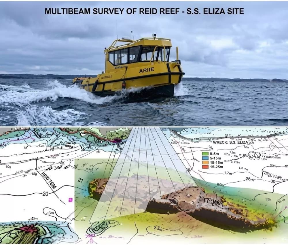
Bathymetric surveys provide information on water depths and seabed topography for environmental studies, marine modelling and project planning.
Services may include:
Definition of survey coverage and accuracy requirements.
Water-depth measurements and seabed profiles.
Preparation of depth contours and bathymetric charts.
Digital seabed elevation models.
Comparison of repeat surveys to assess seabed changes.
Preparation of bathymetric datasets for numerical models.
Survey methods, positioning requirements and reference datums are established according to the intended use of the results.
6. ADCP Deployment and Current Profiling
Acoustic Doppler Current Profiler (ADCP) measurements help characterize current speed and direction through the water column.
ETLCO supports the planning, deployment and interpretation of current measurement programs to provide site-specific inputs for marine assessments.
Depending on the instrument configuration and study design, services may include:
Selection of deployment locations and monitoring periods.
Measurement of current profiles at different depths.
Evaluation of tidal and residual circulation patterns.
Data quality review and processing.
Preparation of current summaries and visualizations.
Use of observations to support model calibration and validation.
Deployment duration is selected to capture the conditions relevant to the study, with seasonal coverage considered where needed.
7. Drone and Aerial Surveys
Drone and aerial surveys provide complementary information on accessible coastal and intertidal areas.
Potential applications include:
Mapping shoreline features.
Documenting coastal construction progress.
Surveying exposed intertidal habitats.
Recording visible erosion or shoreline changes.
Producing aerial imagery and orthomosaics.
Supporting habitat mapping where visibility and survey conditions permit.
Survey arrangements account for access, weather, flight permissions and site restrictions. Aerial imagery is combined with field verification where needed.
Advanced Marine Modelling Studies
1. Hydrodynamic Modelling
Hydrodynamic models assess how water moves within the study area under selected conditions.
Studies may evaluate:
Tidal currents and water levels.
Wind-driven circulation.
Current speed and direction.
Water exchange and flushing.
Changes associated with proposed marine structures or coastal layouts.
Results help explain the physical processes that influence pollutant transport, sediment movement and project impacts.
2. Marine Transport and Discharge Dispersion Modelling
We evaluate the transport and dilution of selected discharges to support outfall planning and environmental assessment.
Applications may include:
Industrial and treated wastewater discharges.
Brine dispersion from desalination facilities.
Thermal discharges from cooling systems.
Transport of selected dissolved constituents.
Accidental release scenarios, where included in the scope.
Studies can compare operating conditions and discharge configurations to identify potential areas of influence and inform mitigation measures.
3. Sediment Transport, Dredging Plume and Erosion Modelling
Sediment modelling helps assess how dredging, construction or changes in circulation may affect suspended sediment and seabed conditions.
Depending on the project, studies may address:
Dredging plume movement.
Suspended sediment concentrations.
Sediment settling and deposition.
Seabed erosion and accretion.
Potential exposure of sensitive habitats.
Comparison of construction methods or operating schedules.
Results support decisions on work sequencing, monitoring locations and measures to reduce environmental disturbance.
4. Coastal and Marine Risk Assessments
ETLCO combines survey evidence and modelling results to assess environmental risks associated with proposed or existing activities.
Assessments may consider accidental releases, exposure of sensitive habitats, discharge impacts and changes in coastal or seabed conditions.
Findings help clients prioritize prevention measures, develop contingency arrangements and identify where additional data or specialist studies are necessary.
5. Two-Dimensional and Three-Dimensional Modelling
We select the modelling approach according to the physical processes, available data and decisions the study needs to support.
Two-dimensional models may be suitable where depth-averaged conditions adequately represent the problem. Three-dimensional models may be needed where vertical variations in currents, temperature, salinity or discharge behaviour are important.
The model setup, assumptions and limitations are documented so that project teams can interpret the results appropriately.
Reliable Data and Transparent Interpretation
The usefulness of a marine model depends on the quality of its inputs and how well it represents site conditions.
ETLCO’s study approach includes reviewing available data, identifying gaps, checking field and laboratory results, and comparing model outputs with observations where suitable datasets are available.
Reports explain scenario assumptions, uncertainty and limitations. Predictions represent the assessed conditions and provide a basis for decisions and monitoring.
Support for Environmental Assessment and Regulatory Review
Our marine studies can support Environmental Impact Assessments, permit applications, construction monitoring and operational environmental management.
We define the scope with reference to applicable NCEC requirements, RCER provisions, project permit conditions and relevant client specifications. Technical support may include preparing study plans, compiling supporting evidence and responding to review comments within the agreed scope.
Final acceptance remains subject to the relevant authority’s review and decision.
Project Deliverables
Depending on the agreed scope, deliverables may include:
Marine baseline and ecological survey reports.
Habitat maps and GIS datasets.
Water and sediment analytical results.
Bathymetric charts and digital seabed models.
ADCP datasets and current assessment reports.
Hydrodynamic and dispersion modelling reports.
Sediment transport and dredging plume assessments.
Scenario maps and visualizations.
Environmental risk assessments.
Monitoring and mitigation recommendations.
Discuss Your Marine Study with ETLCO
Share your project location, study area, development stage, proposed activities and available marine data.
For modelling assignments, include details of discharges, dredging activities or proposed structures, together with the questions the study needs to answer and any authority or client specifications.
Our team will prepare a technical and commercial proposal that connects the necessary surveys, analyses and modelling into a coordinated study.