[av_layerslider id=’12’]
[av_textblock size=” font_color=” color=”]
Modeling atmospheric dispersion of odours allows us to forecast impacts and olfactory nuisance factors associated with the odour sources. The calculations fulfill many purposes in engineering, risk assessments and compliance documentation.
[/av_textblock]
[av_heading tag=’h3′ padding=’10’ heading=’Air Dispersion Modeling’ color=’custom-color-heading’ style=” custom_font=’#a8a8a8′ size=” subheading_active=” subheading_size=’15’ custom_class=”][/av_heading]
[av_one_half first min_height=” vertical_alignment=” space=” custom_margin=” margin=’0px’ padding=’0px’ border=” border_color=” radius=’0px’ background_color=” src=” background_position=’top left’ background_repeat=’no-repeat’]
[av_textblock size=” font_color=” color=”]
[/av_textblock]
[/av_one_half]
[av_one_half min_height=” vertical_alignment=” space=” custom_margin=” margin=’0px’ padding=’0px’ border=” border_color=” radius=’0px’ background_color=” src=” background_position=’top left’ background_repeat=’no-repeat’]
[av_textblock size=” font_color=” color=”]
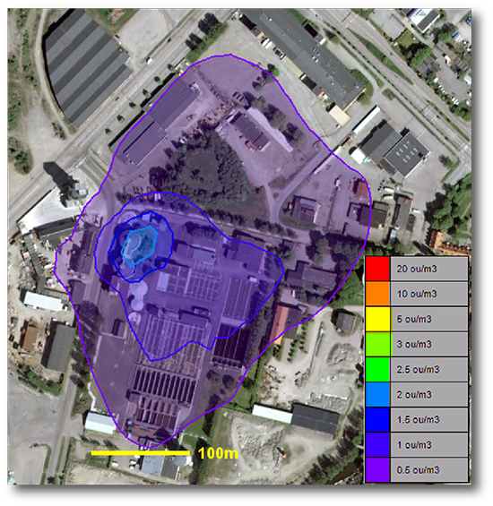
Air dispersion modeling will predict the odour impact based on the measured emissions.
The program will show the worse odour concentration and its duration based on historical weather data.
The model can also show the contribution of each source.
The most common modeling software:
AERMOD (US EPA)
CALPUFF
[/av_textblock]
[/av_one_half]
[av_one_half first min_height=” vertical_alignment=” space=” custom_margin=” margin=’0px’ padding=’0px’ border=” border_color=” radius=’0px’ background_color=” src=” background_position=’top left’ background_repeat=’no-repeat’]
[av_textblock size=” font_color=” color=”]
[/av_textblock]
[/av_one_half]
[av_one_half min_height=” vertical_alignment=” space=” custom_margin=” margin=’0px’ padding=’0px’ border=” border_color=” radius=’0px’ background_color=” src=” background_position=’top left’ background_repeat=’no-repeat’]
[av_textblock size=” font_color=” color=’#939393′]
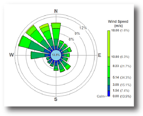
Dispersion model requires the following input:
♦ Meteorological conditions such as wind speed and direction, the amount of atmospheric turbulence, the ambient air temperature, cloud cover and solar radiation.
♦ Source term (the concentration emission, height and temperature of source)
♦ Terrain elevations at the source location and at the receptor location(s), such as nearby homes, schools, businesses and hospitals.
♦ The location, height and width of any obstructions (such as buildings or other structures) in the path of the emitted gaseous plume, surface roughness or the use of a more generic parameter “rural” or “city” terrain.
[/av_textblock]
[/av_one_half][av_heading tag=’h3′ padding=’10’ heading=’Purpose of dispersion modeling’ color=’custom-color-heading’ style=” custom_font=’#a8a8a8′ size=” subheading_active=” subheading_size=’15’ custom_class=”][/av_heading]
[av_one_half first min_height=” vertical_alignment=” space=” custom_margin=” margin=’0px’ padding=’0px’ border=” border_color=” radius=’0px’ background_color=” src=” background_position=’top left’ background_repeat=’no-repeat’]
[av_textblock size=” font_color=” color=”]

[/av_textblock]
[/av_one_half]
[av_one_half min_height=” vertical_alignment=” space=” custom_margin=” margin=’0px’ padding=’0px’ border=” border_color=” radius=’0px’ background_color=” src=” background_position=’top left’ background_repeat=’no-repeat’]
[av_textblock size=” font_color=” color=”]
The purpose of dispersion modeling is :
♦ Document legal compliance
♦ Assess required abatement efficiency
♦ Evaluate impact of process modifications
♦ Calculate required height of stacks
♦ Simulate future scenarios
[/av_textblock]
[/av_one_half]